Mt. Rausu (羅臼岳) – Route Descriptions
Mt. Rausu is one of Hokkaido’s most dramatic mountains, rising sharply above the Shiretoko Peninsula with sweeping views over the Sea of Okhotsk and the Kuril Islands. Both the western (Iwaobetsu) and eastern (Rausu Onsen) routes are long, rugged climbs through prime brown bear habitat. Shiretoko has one of the highest densities of Ezo higuma in Japan, and hikers must carry bear spray, make noise, and follow all local advisories.
1. Western Route (Iwaobetsu Onsen Trailhead)
The classic and most commonly used ascent.
The western approach begins at the Iwaobetsu Onsen trailhead, where a well‑cut path enters dense mixed forest and begins a steady climb along the lower slopes of the mountain. The first hour follows a clear, root‑covered trail through conifer–broadleaf forest typical of Shiretoko’s west side. As the gradient increases, the route transitions into a series of short, steep pitches leading toward the Mizunashi‑no‑kawa stream crossing, a key early landmark.
Beyond this point, the trail steepens significantly, climbing through thickets of Sasa bamboo and emerging onto more open volcanic terrain. The route follows a narrowing ridge with intermittent views toward the Shiretoko Pass road and the Okhotsk coastline. Around the 1,200–1,300 m mark, vegetation thins and the trail becomes rockier, with several loose sections requiring careful footwork.
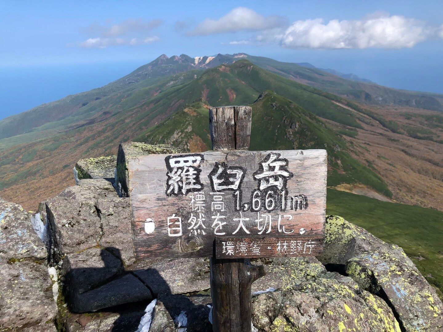
The final approach traverses a rugged volcanic slope beneath the summit block before making a final steep push to the broad, rocky summit. On clear days, views extend across the entire Shiretoko spine, down to Rausu town, and out toward Kunashiri Island. The descent follows the same route, with particular caution needed on the loose upper slopes and rooty lower forest.
Bear Note: The Iwaobetsu side is a known travel corridor for Ezo higuma, especially in early summer. Fresh scat and tracks are common.
2. Eastern Route (Rausu Onsen Trailhead)
A wilder, less‑traveled ascent with a more remote feel.
The eastern route begins near Rausu Onsen and immediately feels more remote than the western side. The trail enters deep forest and climbs steadily along a narrow ridge, with long stretches of enclosed vegetation and limited early views. The lower section is humid, lush, and rich in bear sign — hikers should maintain noise and awareness from the outset.
After roughly 90 minutes, the trail steepens sharply, climbing through mixed forest and bamboo before breaking out onto more open volcanic ground. The ridge becomes more defined here, offering the first views toward Rausu town and the Pacific side of the peninsula. The footing alternates between firm soil and loose rock, with several short scrambly steps.
Higher up, the route merges with the upper section of the western trail near the final summit approach. From this junction, the climb follows the same rocky spine to the summit plateau. The eastern descent requires particular care in wet conditions, as the forested slopes can become slick and muddy.
Bear Note: The eastern side of Shiretoko has exceptionally high bear activity, especially in berry season and during salmon runs in nearby valleys. Encounters are more common here than on the western route.
Difficulty- both routes are a solid 7/10. I recommend preparing for variations in stride length and pacing.
1. Western Route – Iwaobetsu Onsen Trailhead
- Trailhead elevation: ~230 m
- Summit elevation: 1,661 m
- Total elevation gain: ≈ 1,430 m
This is the classic ascent and has the larger vertical climb of the two routes.
2. Eastern Route – Rausu Onsen Trailhead
- Trailhead elevation: ~330 m
- Summit elevation: 1,661 m
- Total elevation gain: ≈ 1,330 m
Slightly less vertical than the western side, but the terrain feels steeper and more enclosed in the lower forest.